Today, we went for a walk in the park.
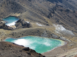 |
The Emerald Lakes, and steam venting out
of the side of the mountain below. |
The park was Tongariro National Park, and the walk was up an active volcano (I am trying very hard not to spell volcano as volcanoe... I don't know why this is so hard for me, but if I slip up, sorry!)
Before volcano-time though, some comments on the names of the towns in the area. The nearest to our hostel is called National Park Village. That's it. That's the name of the town. Hopefully some other village in some other National Park in New Zealand doesn't decide that they want to be called that too, because it doesn't seem very descriptive. And I can't
not comment on the village closest to the volcano - Whakapapa - which has a somewhat unfortunate pronunciation when being shouted across a parking lot... moving on!
 |
| Rock left behind by pyroclastic flow |
 |
| The Red Crater |
 |
| Mt Ngauruhoe |
Due to a combination of volcanic activity and congestion, the road up to the two volcanoes in the park is closed, except for shuttles. So we caught our shuttle bright and early (technically it wasn't bright yet) at 6:45, arriving at the well used trail around 7:30. The hike wasn't as long as we expected, but it was
very different than the mountains at home. We started off on a gradual slope up a valley filled with several lava flows and deposits from pyroclastic (I had to convince Janna that was a word) flows of old eruptions (the most recent in the late 1800s, I think). The bottom of the valley had some shrubs and flowers and grasses, but the further in we went, the less there was, until the last holdouts of lichen gave way to bare rock. A sign marked what is considered the "alpine" zone - again,
very different from what I'm used to. A steep walk up through a few km of bizarre volcanic rocks gave way to an enormous crater - looking around as you crossed it you'd never know you were way up in the air; it felt like a desert.
Up a shoulder out of the crater, eventually reaching the turn-around point, from which we could see the Red Crater, the Emerald Lakes, and Blue Lake - and some steam venting out of the side of the bluff below us. This hike is usually a crossing, but the northern half is closed due to a "volcanic eruption hazard".
Also along this hike is Mount Ngauruhoe - more widely know as Mount Doom in the Lord of the Rings. The first half of the hike goes up its bottom half - it takes on its iconic cone-shape at the above mentioned crater of neighbouring Mount Tongariro. Naturally, we took a picture. Or ten.
 |
Okay, this looks like a HUGE bite, but
I swear that's just the angle of the camera...
it really wasn't!!!! (now nobody will believe me...) |
In other news, bread here is very thinly sliced, resulting in triple-decker peanut butter and jam sandwiches.
- Marysa


No comments:
Post a Comment